The Punch Bowl

  • About
  • Food
    • Sample Menu
    • The Punch Bowl at Home Menu
  • Rooms
    • Late Availability
    • Noble
    • Danson
    • Hebblewhite
    • Whitelock
    • Cooper
    • Birkett
    • Heelis
    • Peake
    • Strickland
  • Weddings
  • Events
  • Journal
  • Gifts
  • Contact
  • At Home

Walks starting from the Punch Bowl

​Lords Lot

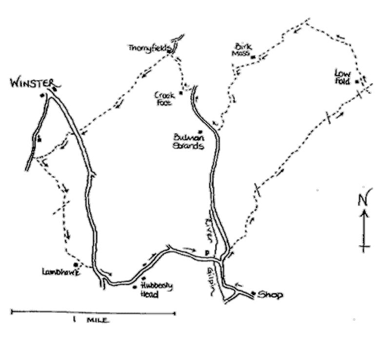
A  4 hour walk (9 miles) well away from the crowds, which can be done as two 2¼ hour walks.
​

  1. From the Punch Bowl, turn left and walk through the village, past the school and village hall.
  2. Turn right, the road signed Starnthwaite and Crook. After the junction with the Hubbersty Head road, keep straight on for about 75 yards. Take a track on the right signed: Footpath, Low Fold. After about 300 yards look for a gate on the left and a yellow arrow on a post. The path is not at first obvious in the field, but bear right and you will see a row of hawthorn trees on the edge of a bank. Keep these on your left. At the end of the row, turn left through a gap in what was once a wall and follow the ill-defined track. Bear right before you reach the small beck and look for a gate with a stile at the junction of a wall and a fence. The path ahead is much more obvious as it winds uphill between gorse bushes.
  3. [This area is Lord’s Lot — after the Enclosures Act, in the 18th Century most of the common land was allot-ted to landowners and the allotments were frequently abbreviated to “Lot". The “Lord” was probably the lord of the manor.]
  4. Near the top of the hill you will get good views of the Kent estuary, the end of Whitbarrow and the ridge of Cartmel Fell.
  5. As the path levels off, follow the fence on your left through a marshy area.
  6. [Notice here the sphagnum moss (used in World War I for dressing wounds because of its absorbency), marsh pennywort which derives its name from the shape of its leaves, and in summer the yellow spikes of bog asphodel.]
  7. Follow the fence to its end, then over a stile into a field. Bear slightly left and aim for distant trees. Over the brow of the hill, the path becomes more obvious again and leads to a ladder stile and a farm track. Bear right here and then turn left along the track to Low Fold.
  8. [Notice the steps to assist with mounting your horse at the front of the house. The owner of this house (and several others) in the 18th century made his fortune as a mole catcher to the Duke of Buccleugh in Scotland.!]
  9. Continue on the well used track through a gate with a gnarled ash tree as a gatepost and uphill to a gateway after which there are good views of the Lakeland fells. The track ends in a field near a large oak tree underneath which a yellow arrow shows the direction to take across the field, via another yellow arrow, to a ladder stile in the corner. Bear left to cross the next field and join a track alongside the wall. Through the gate, turn left at the road and go over the cattle grid following the drive to Birk Moss. The bridleway has been diverted to avoid the farmyard — follow the blue arrows to the left of the buildings and then bear right. Over the brow of the hill, the path is just visible, continue to a T junction with a low finger post where you turn left on the bridleway to Bulman Strands.
  10. Pause to admire the views including Heysham nuclear power station.
  11. Continue down this path, turning sharp left through a gate with a blue arrow into a walled lane.
  12. [Puzzle — what is the oblong structure made of stones? Did they just have too many when they built the walls?]
  13. After the next gate, follow the blue arrow down the field, go between a sycamore and a short row of hawthorns and then more sharply left to a gateway. Follow the beck on your right down to a wooden gate onto the road.
  14. {You are now approximately half way round the long walk. If you have had enough for today, turn left and follow this minor road back to Crosthwaite. To continue, turn right.}
  15. Continue or restart the walk by passing Bulman Strands. Take the bridleway on the left which starts down the drive of Crook Foot but turns right after a bridge over the river.
  16. [Note the round chimneys which are characteristic of many old farmhouses in this area.]
  17. This well used lane leads through an iron gate and towards a group of houses.
  18. Turn left at Thornyfields and up the bank, keeping to the right of the barn and then turning left through a gate beside it. The track follows the line of the wall on your left, climbing up steadily. Another gate, then between the gorse bushes to the summit where a kissing gate takes you into an open field but with the path still visible. A pond on the left is worth a few minutes quiet observation for its wildlife interest — moorhens, dragonflies, tadpoles? Views of the Winster valley and the Coniston Fells can be seen as you start to drop down with a tumbling beck on your right. A gate leads you onto the A5074.
  19. (You can return to Crosthwaite by road from here, but it is a busy, narrow road and not recommended.)
  20. Cross the road and take the bridleway signed to Bryan House Farm. A wooden gate in the right hand corner of the field leads into a walled lane with a stone footbridge over the beck. Continue up, through a gate, and then down towards the farm with Winster church visible on your right. After the next gate, and about 30 yards before joining a minor road, turn left on the path signed to Lamb Howe. Go through the gate and follow the track to the left of the wood. Continue through another gate under a large wild cherry tree and follow the track as it winds between fallen walls and piles of stones.
  21. [Notice the traditional gateposts in this area — instead of a hinged gate they consisted of poles slotted into holes in the gateposts.]
  22. A post with a yellow arrow directs you between two concrete gateposts. At a junction with another path, follow the sign to Roper Ford. The path almost disappears in the gorse and bracken, but bear right and you should emerge in the corner of the field with a wooden ladder stile on your right and a stone stile on your left. Take the stone stile and follow the wall on your right. Just after the next gateway, climb the ladder stile on the right and continue between the hedge and a tall fence. Another ladder stile leads into an open field — keep left across the field to a metal gate and then another gate leading you down Lamb Howe farm drive (ignore a yellow arrow on a gatepost to the right).
  23. At the road turn right for 100 yards, then take minor road on the left signed Hubbersty Head and Starnthwaite, which will return you to the road to take you back to the start of your walk.​
​
Picture

​Starnthwaite Short Walk

(1¼ miles each) from Crosthwaite.

  1. From the Punch Bowl, turn left.  Walk through village, past school and village hall. Take the turning signed Crook and Starnthwaite, and follow the same sign at the Y junction. Continue on this minor road to Starnthwaite Ghyll where a bridleway sign on the left takes you down the drive.
  2. [Note that the river passes under the main building. Water power was used here for paper making from 1709-1849, then for making bobbins. In 1885 it was a sawmill. By 1906 the buildings had been converted for the use of ‘Starnthwaite Colony and Epileptic Boys Home’ which aimed to “save youths and men from the listless apathy produced by workhouse life" - To get an idea of how it would look in its industrial hey-day, visit the Stott Park bobbin mill near Lakeside.]
  3. Continue round the corner of the main building, through the car parking area to the wrought iron gates. The footpath is visible and takes you through 2 small sections of field and onto a track beside the river. Cross the minor road to a stile and continue beside the fence to the next stile, which has two yellow arrows.
  4. To return to the village, follow the left-hand arrow to a kissing gate by the river. Cross the footbridge, turn right at the road and retrace your steps to the old shop located by the village phone box.
  5. To extend the walk, follow the other arrow. Continue in this same direction over 4 stiles (3 of which have yellow arrows), crossing a tarmac drive. In the next field look up-hill for a post with an arrow directing you to a stile into the road, turn left. (Be careful of the traffic).
  6. Follow this road over the bridge and back into the village.​
Picture

THE PUNCHBOWL

Menus
Rooms

Late Availability​
Location
Weddings
Gift Vouchers
The Punch Bowl at Home

HOW TO FIND US

​​The Punch Bowl Inn,
Crosthwaite,
Lyth Valley,
LA8 8HR

​
015395 68237

ENQUIRIES

info@the-punchbowl.co.uk

THE PUNCH BOWL AT HOME

athome@the-punchbowl.co.uk

​
​​Accessibility Statement  |  ​Privacy Policy  |  ​Cookie Policy  |  ​Website by Treble3  |  ​ ©2021